River waterfall and natural pools
The water is crystal clear – fed from the rain forest above. There were lots of little fish swimming all around us as we waded through the river.
Stay out of the rivers when it has been raining, flash floods are common. Some of the rocks are slippery, so be careful. There are no facilities here (such as bathrooms, etc.), please carry out your trash, this is soon to be a trash-free zone.


Deep Hole Pool


Dream like avatar movie
Bioluminescence in Toro Negro Forest Ponce Puerto Rico
Cucubano Puerto Rican
The Cucubano Puertorriqueño, scientifically known as Pyrophorus luminosus or Ignelater luminosus, is a bioluminescent species of click beetle native to Puerto Rico. It is a slow-growing species, taking several years to mature, and typically measures around 3 centimeters in length. The beetle’s body is elongated, slender, and flat, with a general coloration of black or chestnut.
Characteristics
- Native to Puerto Rico
- Bioluminescent, emitting light from the thorax
- Slow-growing, taking several years to mature
- Elongated, slender, and flat body
- Typically 3 centimeters in length
- Coloration ranges from black to chestnut
- Conservation Status: Although there are no scientific studies confirming its endangered status, the cucubano puertorriqueño is considered vulnerable due to ongoing environmental pressures.
Interesting Facts:
- The cucubano puertorriqueño is a nocturnal insect, and its bioluminescence is used for communication and mating.
- Locals often refer to it as “cucubano” in Spanish, which translates to “glowing click beetle”.
- Some species of click beetles, including the cucubano, have destructive larvae that feed on crops and gardens, leading to conflicts with farmers and gardeners.
Dona Juana Falls

Charco Confesora

San Cristobal Canyon

located in the municipalities of Barranquitas and Aibonito, at an elevation ranging from 748 feet (227.8 m) to 2,140 feet (652.2 m) in Puerto Rico’s Metro-Central Region. The area owes its name to its most outstanding topographic feature, the Cañón de San Cristóbal (San Cristóbal Canyon). Extending for approximately 5.6 miles (9 km) in the heart of Puerto Rico’s Cordillera Central, the Cañón de San Cristóbal is a unique geomorphological phenomenon resulting from tectonic movements that caused the rise of the superficial terrestrial crust along the region. It is one of the most spectacular and significant geological features in Puerto Rico and the Caribbean. With the erosive action of the Río Usabón still sculpting its way along the canyon’s bottom, the structural characteristics of the canyon have led to the establishment of exceptional and unique ecosystems and biological communities that are home to more than 749 species of plants and wildlife. Its rocky riverbed captures the waters of an elaborate system of tributaries throughout its nearly 6.52 miles (10.5 km) of length, creating waterfalls and natural ponds including the breathtaking Salto La Vaca, the highest waterfall in Puerto Rico at approximately 300 feet (91.4 m).
After many years of neglect and misuse as a waste dump by
nearby municipalities, and following a public campaign to protect the area
started in the 1960s, the Conservation Trust of Puerto Rico was able to acquire
most of the private properties within the canyon by 1974. It currently manages
nearly 1,521.41 acres of land protected by the CSCNPA, and along with an
aggressive array of conservation and restoration measures that have been put in
place since then, it has transformed the area from a foul and disregarded site
to the pristine and highly prized natural treasure it is today.
The establishment of a tree nursery in the CSCNPA has been significant in implementing reforestation efforts in its forests, and together with management facilities and offices operating on site—which include a historical house (Casa Laboy)—they have effectively contributed to the Conservation Trusts’ efforts in securing the functionality and health of the area’s ecosystems.
Charco Azul en Ponce

Bird Watching


Basics of Hiking in Toro Negro Forest

Though there are various forest regions in Toro Negro, all of the hiking trails are located in one area. That would be near the administration office / ranger station on Route 143 KM 32.4 in Villalba. The office is open Monday- Friday, and they will supply you with maps and other info about the forest and trees (all in Spanish). Note 8/14- One of our readers said no one is working here anymore- so print out this article and bring it with you as a map.
The map they give you is OK, but after hiking around and talking with one of the rangers, we found that their map includes trails that no longer exist. So, with the info we got from the ranger, and the data we got from our GPS unit we made a better map!
There are really only about 6.75 miles of trails all total, so with an early enough start, a little planning and the stamina, you can hike all of the trails in a day. We didn’t hike on all of the trails — we only hiked about 4.9 miles the day we went. But there was still plenty of daylight left.
One weird thing about hiking here is that a number of the "trails" require you to walk along the road in order connect to another trail (to make a loop) or to get back to the parking area. These are small roads that have blind curves and, though they are infrequently-used, it was a bit unnerving.
In general, the trails are wide. Some trails are access/maintenance roads used by the staff, so those trail heads are blocked from vehicular traffic with a green gate. You are allowed to walk around the closed gate. There is an occasional sign along the trails, but don’t expect to find a lot of direction along the way. This forest is not used much — only 2 other parties signed in at the office the day we went.
El Bolo tower

El Bolo Trail. This trail head is across the street from the parking area (it starts out as the driveway for the forest maintenance area). This is a wide trail, that goes from forest to field and back to forest. It has lots of bananas and wild flowers along the way. It’s pretty and well-maintained. It starts off with a steep uphill climb, but eventually flattens out. It was rocky at first but became an earthen/grassy trail.
Toward the top of the trail, it meets the paved road that goes to the right — we continued on the trail to the left. After that, this trail loops off to the left. You can take this trail all the way back down to Route 143, where you have to walk on the road about ¼-mile to get back to the parking area. Or, you can go farther uphill to the right and go on the Observation Tower Trail.
There is a sign that says El Torre for the trail to the Observation Tower. This trail was difficult — it was uphill and slippery … REALLY slippery. It is about 0.6 miles one way. It took us a while on both the uphill and downhill parts. The trail is made of rocks and, since these trails don’t get much use, the rocks were covered in algae. We ended up walking in the muddy area on the side of the trail (which was also slippery, but a little less so).
But when we finally made it to the tower we found some really lovely 360° views. And a great breeze! The tower is about 3537 feet above sea level — so you can see for many miles! The distance from the office to the tower is about 2.14 miles.
The trail to the tower is a dead end, so we went back down the slippery trail until we got to El Bolo Trail. Then we back-tracked on El Bolo Trail until we got to the intersection with La Piscina Trail.
On La Piscina Trail

This trail is nice. From El Bolo Trail, it goes down hill through the forest for about 0.8 mile before ending on Road 143. The last part of it goes through 2 picnic areas (where we stopped and ate our picnic lunch) and you come to the river-fed "swimming pool" (La Piscina). This DRNA recreation area had an old river-water swimming pool. But when we visited, the swimming pool was in disrepair and closed. They have repaired it and were going to open it in 2016…But it never opened. Hopefully some time in 2019? If it does open, it will only be open during summer months.
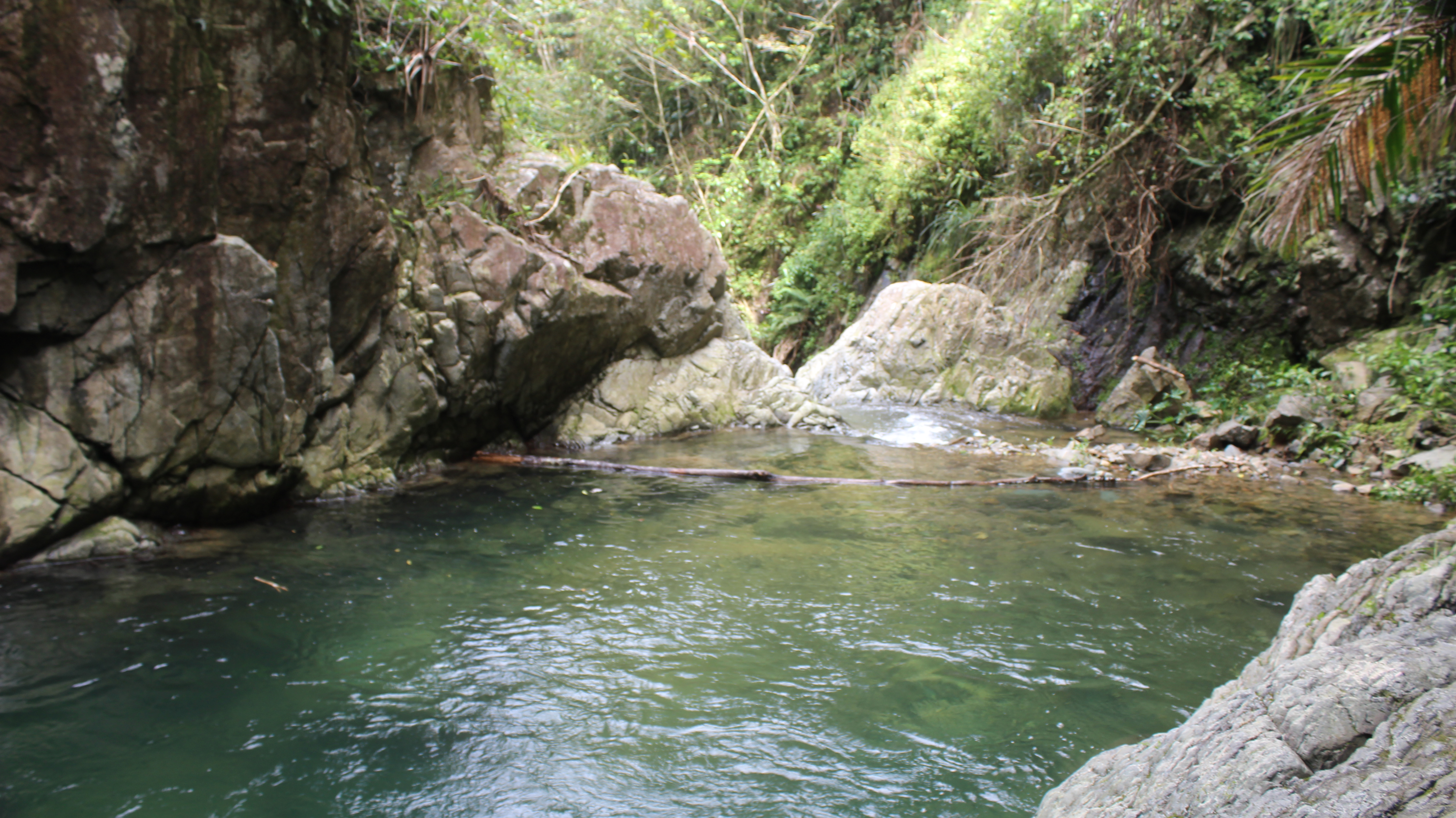
Continuing down the trail a little past the swimming pool (just before the road), you will come to a small side path that leads down to the river where there is a pair of very pretty waterfalls and a small natural pool. Back on the main trail, you will end up on the road and must walk a little bit (about ¼ mile) on the road to the left to get back to the parking. It was here we had a 15-minute rain shower.
More hiking Toro Negro
at 4390 feet, is the highest point in Puerto Rico. If you drive west on Route 149, you will eventually drive very close to Cerro Punta. You can identify it by the radio and communication towers on it.
The forest is open every day for hiking. The administration office / ranger station may be open weekdays from 7:30am until 4:00pm. Call 787-867-3040 to make sure. Given the small, winding, shaded roads that lead into the forest, it’s probably smart to plan on driving out of the area before it starts getting dark (5pm or so).
Bring everything that you will need for the day — food, water, etc. There is nothing available for purchase in the forest. There are restrooms in the building behind the administration office and in the campsite area.
Allow at least 2 hours to see some of the forest. If you get an early start, you could easily hike all of the trails in one day.
Don’t believe all the trails on the map that they hand out at the DRNA office! Trail 2 and Trail 4 on their map are just DRNA maintenance routes — short in and out roads, not really hiking trails. We never did find Trail 10 from their map, and the ranger said not to bother looking for it. Also, their map shows a trail that cuts across from Trail 5 to Trail 9 without having to go on the road. The ranger said that this trail does not exist. Save yourself a headache and print out our trail map and take it with you.
Driving directions from San Juan — Take Route 52 South/Sur as if you were driving toward Ponce. Continue on Route 52 to the Juana Diaz exit (Exit 91 – toll ). After the exit, turn left at the light onto Route 149 North/Norte. Follow this road for about 30 minutes. You’ll be looking for Route 143 East/Este. You’ll come to a left turn for Route 143 West/Oeste before you get to Route 143 East/Este. Do NOT turn left onto Route 143 West/Oeste. Stay on Route 149 (to the right). Continue on Route 149 until you see the Toro Negro Forest sign and Route 143 East/Este to the right. The administration office is on Route 143 East/Este at KM 32.4. If you’re traveling to the forest from the north, get a good map and try to take the largest roads you can find!
Route 143 is part of the Ruta Panoramica. There are some really scenic points along the way. But realize these are small and twisty roads. You cannot drive fast — in fact I think it had a speed limit of 15MPH. Though in many parts people drive faster. Also, be aware that people drive closer to the middle of the road, so be REALLY careful when going around curves — there may be someone coming the other way in your lane!. Many drivers and large vehicles will honk — so keep an ear open, slow down and move to the right! I try to limit my travel times on these roads and try to get off them before it gets dark. If you are prone to motion sickness, buy some Dramamine and medicate early!
Escape to El Campo Es Leña


Comentarios
Publicar un comentario